Hiking the River Link-Schmid Preserve
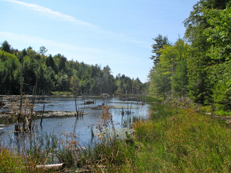
 The River Link trail system carries hikers through the Schmid Preserve in Edgecomb where there are a number of intersecting side trails, one leading to the marsh shown here. PHIL DI VECE/ Wiscasset Newspaper
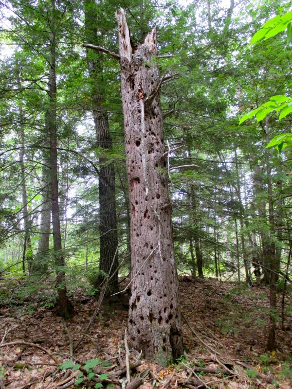
 This strange tree looks like it belongs in the Land of Oz but can be found in Schmid Preserve not far from the Old Country Road parking area and trailhead. PHIL DI VECE/ Wiscasset Newspaper
 The River Link trail system carries hikers through the Schmid Preserve in Edgecomb where there are a number of intersecting side trails, one leading to the marsh shown here. PHIL DI VECE/ Wiscasset Newspaper
 This strange tree looks like it belongs in the Land of Oz but can be found in Schmid Preserve not far from the Old Country Road parking area and trailhead. PHIL DI VECE/ Wiscasset Newspaper
If you're looking for a good overland workout, try traversing the Schmid Preserve-River Link Trail System. On one juncture, it stretches five miles from Edgecomb to Dodge Point Preserve in Newcastle. This is a trek not recommended for beginner hikers.
You can start hiking here at several different points and still get a good workout. A good place to begin the River Link is from its entrance off McKay Road. From Route 1, take the Route 27 exit in Edgecomb by the Cod Cove Inn and head toward Boothbay. The McKay Road is 3.7 miles from here and on the left; it's not far past the Edgecomb Potters. (The turnoff is on a curve and comes up fast.) The trail kiosk and parking area are a half-mile down the road on the left.
There were plenty of trail maps here for both the River Link and Schmid Preserve when I hiked here last Saturday. (I went in as far as Mount Hunger and back.) Even with a map, it’s always a good idea to carry along a compass, or GPS device and cell phone. Trail shoes are recommended.
The trail begins behind the kiosk. It’s marked with small white squares with a picture of a green pine cone. You'll find these periodically tacked to tree trunks and occasionally on wooden posts at intersecting trails. After crossing a wooden footbridge, the path begins to climb slowly.
Just ahead is a towering rocky knoll on your right. It rises 321 feet and is the highest point in Edgecomb. On my topographical map it's marked, “Mt. Edgecombe.” You'll note the “e” on the end, which is an earlier spelling for Lord Edgecombe, and the town's Colonial namesake.
The hill's had other names over the years including, “Bill John Williams Hill” or simply “Williams Hill.”
According to legend, this area was once known as the “King’s Woods” because during the time of King George, the towering pines that grew here were marked with a broad arrow to be used as masts for the Royal Navy. Today Northern White Pines again cover the high hill.
From here the path continues in a northerly direction surrounded by woods, dense at times. You'll pass many side paths probably left behind from an earlier logging operation. Respect the wishes the river link partners and keep on the marked trail. You'll see many crisscrossing stonewalls along the way. The trail eventually winds around a small brook, just a trickle now due to an unusually dry summer. A series of moss-covered boulders serves as a natural bridge over it.
Not too far after you cross the stream, you'll come to a fairly large, intersecting path; together the two trails form a sort of “T.” There's a wooden post marking the River Link Trail, although you're now also on the Schmidt Preserve.
If you're adventurous, take the left path running southwest. (You'll find it marked but unnamed on the Schmid Preserve map.) A short ways along you'll see another path veering off on the right. This carries you uphill to where an old stone well is located. The trail ends at a tumbling stone wall that marks a boundary line of the preserve.
Although the path continues, respect the rights of the abutting property owner and return the same way you came. Going right where the paths meet brings you to a large swamp marking another boundary of Schmid Preserve.
Returning to the post marking the River Link Trail, you can either backtrack to McKay Road on the same trail that brought you here, or continue exploring the Schmid Preserve. If you decide to call it a day, it's about a 30-minute walk back to the McKay Road trailhead. Keep in mind if you're hiking late in the afternoon and it's getting toward evening, darkness comes quickly in the woods this time of year.
If you continue on, you'll see the path soon widens into an old wagon road. The River Link Trail will veer off on a smaller path to the left while the road continues northwards past what remains of the old mica mine. Here you can see where mica and feldspar were quarried in the late-19th century. The road eventually brings you out to the Schmid Preserve's parking area off Old County/Mt. Hunger Road. The hike here from the McKay Road trailhead is just shy of two miles.
A short distance from the Old County Road kiosk is Mt. Hunger itself. Continue east down Old County/Mount Hunger Road, at the bend in the road you'll see the Ridge Trail blazed in blue paint on your left. Follow this uphill until the trail intersects with a stone wall, to your left is Mt. Hunger. Although it rises over 280 feet, the incline is barely noticeable because of the trees. No one seems to recall how this hill got its unusual name.
There are many other interesting trails to enjoy within Schmid Preserve. During my recent visit, I ran into three other hikers who, like myself, had spent close to two hours exploring the area and enjoying a beautiful fall afternoon.
The Schmid Preserve was a gift to the town of Edgecomb in 1979 from Charles and Constance Schmid. Volunteers maintain the expansive preserve and trail system. No overnight camping is permitted, or open fires allowed. ATVs and other motorized vehicles are prohibited. Hunting is permitted during hunting season, which begins Oct. 1. (Maine does not allow hunting on Sunday.) Dogs are allowed here, but should be leashed during hunting season. For more information, go to www.edgecomb.org/boards/schmid
The River Link was established in 2003. The same rules apply; no motorized vehicles are allowed and no overnight camping or open fires. Partners of the River Link refer to this as, “a back-country trail of moderate difficulty.” Before tackling the 5-mile leg, first try hiking to Mt. Hunger Road and back from the McKay Road trailhead — a distance of about about four miles. Remember whatever you carry in, be respectful and carry out.
Event Date
Address
United States


