December 1929
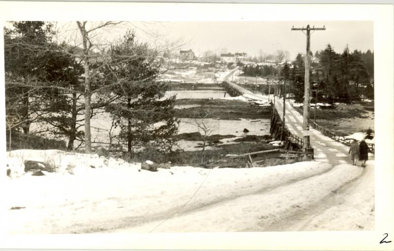
Anyone who's lived on the coast in the winter knows this view, the aftermath of a typical coastal snowfall. It comes down hard for a few hours, scattering about eight inches or more of snow. Then the temperature rises above 32 degrees, melting much of the snow and making a slushy white mess mixed with the brown of unpaved roads or the sand spread by the town on paved roads.
The Knickerbocker and Day Bridges
This view of Boothbay's Knickerbocker bridge was photographed by the state in December 1929 in conjunction with their policy of taking over or aiding towns with their bridges and some roads. The vantage is from Hodgdon's Island looking east downhill to the bridge. The bridge section from Hodgdon's Island to Knickercane was known as the Day bridge, for Merrill Day in that era. The Knickerbocker bridge ran from Knickercane to the mainland. High up the hill on the mainland is the prominent white Reed house, owned by John Reed for most of the late 19th century. I believe the Joses live there now.
The view takes you back to an earlier time, predating paved region roads. The first paving project, from Route 1 to Boothbay Harbor, was funded by the state in 1925 and that took years to complete. Town-funded projects were much shorter stretches and took even longer to approve. I'd take a wild guess that 90 percent of the town roads were tarred by the 1970s.
Plowing, Salting, and Sanding
The view also predates the incessant plowing and salting and sanding the towns now do. Even in 1950s East Boothbay, the Soler boys and I could start our sleds or toboggans on Route 96 by the turn to Paradise Point on Priest's Hill, glide north nearly to Doug and Stella Hodgdon's corner store, pull the sleds just 100 feet or so to the top of the next rise by the store, then slide down all the way past the shipyards. In the mid-1950s, there just weren't enough cars on the main roads to make it risky. However, I'm sure we didn't tell our parents about our half-mile ride through the village. Plentiful cars and immediate attention to clearing the roads ended those escapades long ago.
In 1929 Boothbay voters approved money to rebuild the Barters Island, the Day, and the Knickerbocker bridges, with cash infusions from the state and county. The following year the town voted more money, requested by the state, which provided the plans and specs for the job. In July 1930 the future bridge was described by the War Department and the State Highway Commission as being straightened and north of the old one (just as 2011's is south of 1931's). The Day bridge section was packed solid with 1,860 cubic yards of fill, becoming a causeway. The new Knickerbocker bridge was dedicated a year and a half after the December 1929 shot was taken.
Getting Around
Getting back to that shot, it shows a then-daily scene. In the time before cars ruled the roadways in town, people walked, if they couldn't go by water. Children walked up to two miles to school; everyone walked to the store and to work, if work was outside the homestead as it was for many men at least part of the year. Wherever you went over land, you walked, and if you had a hefty load to haul, you took a wheelbarrow. If you had a big load, you took a critter, such as a male or female ox, to haul it, since few owned horses.
Just as each region locality had a schoolhouse, more than 20 at one time, almost every one also had a store. Normally the schools and stores were about two miles or so apart. I think the two women are doing what men and women did for more than 100 years since 1850, walking east home to the mainland from the S. G. Hodgdon store on Hodgdon’s Island.
Event Date
Address
United States

