Struggling with change in the 1920s, part III
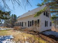
 The 1922 Sanborn insurance map shows a stretch of Townsend Avenue from its intersection with Oak Street on the left north to Pottle Realty on the right, extending about halfway to Union Street. The large amount of vacant space east behind the houses is obvious. The one structure that seems to bar passage of a waterfront road is the addition on the east end of the present A Silver Lining; that addition has the legend "Open 1st" meaning one could pass under it. The arrow shows its location. Courtesy of Boothbay Region Historical Society
The 1922 Sanborn insurance map shows a stretch of Townsend Avenue from its intersection with Oak Street on the left north to Pottle Realty on the right, extending about halfway to Union Street. The large amount of vacant space east behind the houses is obvious. The one structure that seems to bar passage of a waterfront road is the addition on the east end of the present A Silver Lining; that addition has the legend "Open 1st" meaning one could pass under it. The arrow shows its location. Courtesy of Boothbay Region Historical Society
The 1922 Sanborn insurance map shows a stretch of Townsend Avenue from its intersection with Oak Street on the left north to Pottle Realty on the right, extending about halfway to Union Street. The large amount of vacant space east behind the houses is obvious. The one structure that seems to bar passage of a waterfront road is the addition on the east end of the present A Silver Lining; that addition has the legend "Open 1st" meaning one could pass under it. The arrow shows its location. Courtesy of Boothbay Region Historical Society
This series of article covers the clash of age-old land-based transportation and the coming of the motorized age. The struggle in the region, in the form of tax money, culminated in about 1926 and 1927. In conjunction with that clash, last time I wrote about Lester Barter's memories of the route a waterfront road took or might have taken parallel to Townsend Avenue, but nearer the water. Lester remembered it as an old road that was to be resurrected and formalized at the 1926 town meeting.
Just as Lester wrote, the waterfront road did come up at the 1926 town meeting, only it was a little more complicated. A year earlier a committee had been formed, consisting of George Gregory, Robert Watts, and Ed Hutchinson, to study the Harbor's traffic. They came up with 11 suggestions which were discussed at the 1926 meeting in the 49th of 106 articles. They included improvements to roads such as West, Commercial, and Smith streets. They proposed that Townsend Avenue become one way south into the Harbor, with parking on both sides, and Oak Street one way out. Water Street (now the By-Way) was to be one way exiting at Bridge Street as it does today.
The committee's waterfront road
An ambitious part of the committee's plan was to take over sufficient land for the waterfront road Lester remembered between Bridge Street and Union Street, thus connecting to Pear Street. Given that the By-Way had become a town road, the waterfront road actually extended to Wharf Street. Certainly parts of the road already existed for access to the backs of houses. Homes often had access from front and back, particularly bank houses where the front first floor is the rear's second floor due to the steep grade of the bank. There are some bank houses along that harbor route. And along Lincoln Street in East Boothbay, which formerly had many bank houses on the river, I saw indications in deeds of a road, long forgotten, along the backs or river sides of the houses.
In the case of the harbor waterfront, Lester pointed out that the 1878 Miller building, which houses Tony Heyl's A Silver Lining, has an elevated section in the back to allow passage under it. While it might seem like a long way to the water, the back of that building was nearly at the water's edge before fill was dumped. And the waterfront road? Some of us, like me and girlfriends and John and Judy Hodgdon, regularly walk north along Townsend Avenue on that phantom road—not on the avenue but east below threading our way about 1,000 feet through the businesses' parking lots on the water from the footbridge more than halfway to Union Street.
Perhaps the townspeople were reluctant to spend the money required to buy the bits of land needed for the road, or vehicle congestion had not loomed large yet, or people objected to their property being divided by a road. Vehicle congestion was coming, but not here yet, and there was still hefty resistance to tax money benefitting motorized vehicles — they required better conditions than horses and oxen. Whatever the reasons, the recommendation was turned down, as Lester said was the case. The road might have been a great help to traffic today, particularly if it didn't merge with Townsend but handled traffic headed for East Boothbay.
Item by item, article by article
Roads were perennially one of the town's main concerns but particularly in the mid-1920s — besides the committee's recommendations, 30 more articles in 1926 proposed work on specific roads. Subsidiary road matters of sidewalks and streetlights took up another 14 articles. In that era upkeep or improvements were voted on at town meeting piecemeal, a typewriter (article 51), a road, and a streetlight at a time, such as the light to be located between C. C. Colby and D. A. Greenlaw on Commercial Street (article 62). The voters knew exactly what was at stake and how much was to be spent to the item level. That's why town meeting broke for lunch in the old days. Not so now — last year, Boothbay's whole municipal budget was in one article. The trend had been going that way for a long time.
Other 1926 transportation articles were all over the map and contradictory, which follows from the period's conflict between age-old ways and new ways. Articles included pedestrian suggestions, such as articles to discontinue the footbridge, or fund it, or collect tolls; and to build a footbridge across Mill Cove from Albee's Point (end of Commercial Street Extension) to Wylie's Point (also Spencer's or Hospital Point). It was another 20-30 years before cars made walking overwhelmingly secondary.
The towns were floundering around trying to keep up with the times' growing and relentless attachment to the gasoline engine, while trying to appease those who thought that direction was a bunch of hooey. But as it turns out, we all have cars today and value new-laid tar, like that on the Beath Road. Cars were winning in 1926, but the skirmish for the waterfront road went down to defeat.
Event Date
Address
United States